With misty mountain passes in the north, bumpy rice field-flanked tracks in the south and glorious coastal highways stretching along its spine, Vietnam just begs to be explored on four or – more commonly – two wheels.
With more than 61 million motorbikes for just over 96 million people, scooters rule the roads here, meaning intrepid bikers will find themselves in good company as they traverse the country’s wonderfully diverse landscapes, with ample repair shops, gas stations and those all important food stops along the way. Whether you’re thinking of hitting the road in a car or motorbike, here’s our pick of Vietnam’s best road trips.
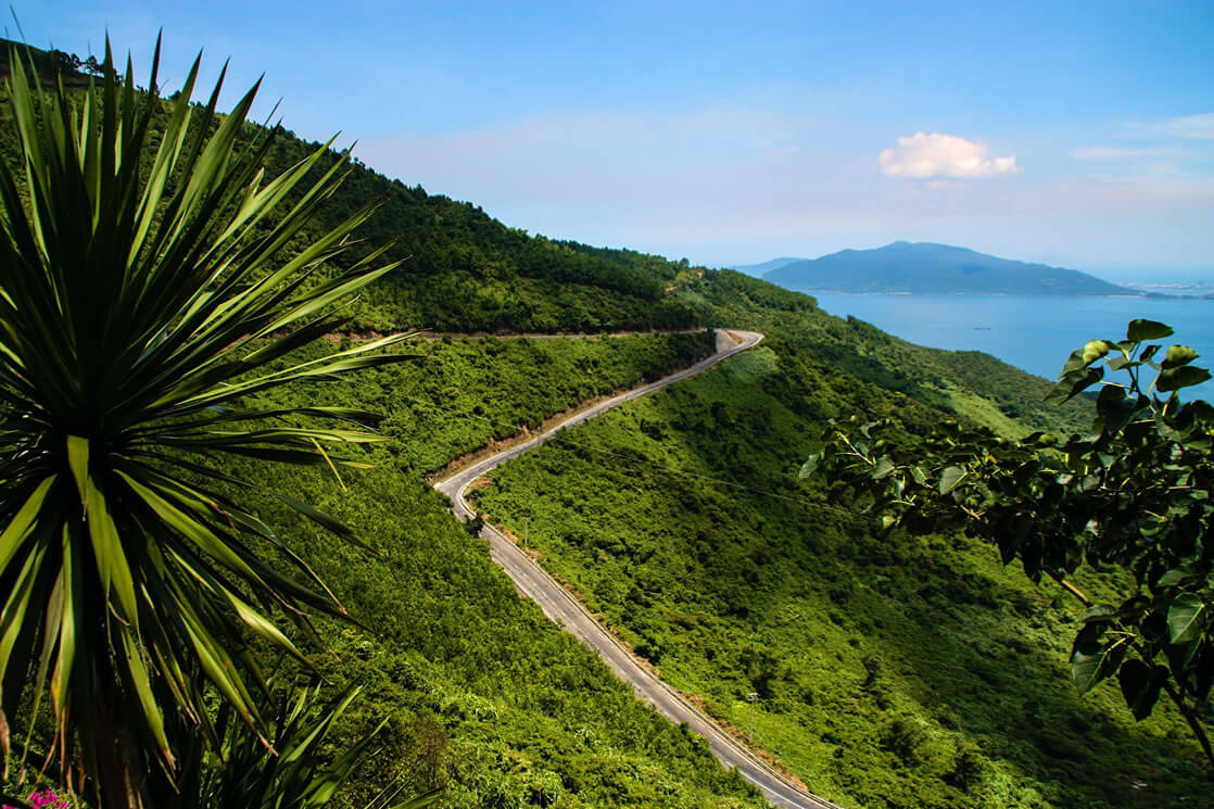
Hai Van Pass
Start – Danang; End – Lang Co Beach; Distance – approx 20km/12 miles
Before the Hai Van Tunnel was completed in 2005, just the thought of enduring the hairpin turns and blind corners of the Hai Van Pass was enough to send shivers down the spine of many a bus passenger traveling between Danang and Hue. Now with significantly less car traffic, this short but stunning ride is relatively easy to handle even for the novice driver.
Translating as ‘Ocean Clouds’ in Vietnamese, the Hai Van Pass is bordered by jungle-clad mountains on one side and cliffs plunging down to the East Sea on the other, a dramatic setting that has made this road one of the most Instagrammed in the world (with a whopping 4298 pictures per mile!). Stop at the mid-way point for a Vietnamese iced coffee, and admire the Indochina-era Hai Van Gate and the remains of several French fortifications. While the pass officially ends at the windswept Lang Co Beach at its northern end, most travelers will continue another hour or so to the former imperial city of Hue.
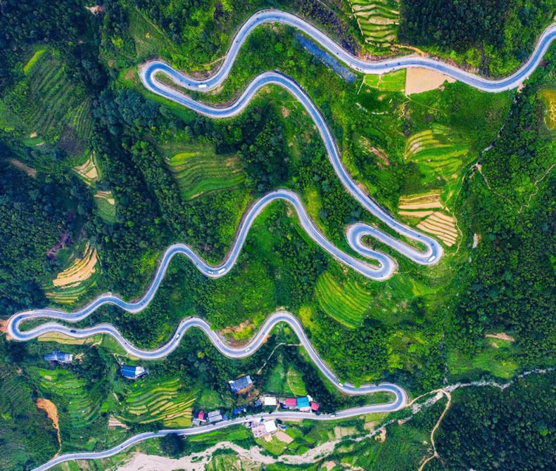
Ha Giang Loop
Start – Ha Giang; End – Ha Giang; Distance – approx 350km/218 miles
The soaring peaks and plunging valleys of Vietnam’s northernmost province are best enjoyed at a leisurely pace, with plenty of stop-offs for revitalising dips in waterfalls, roadside snacks (nothing keeps energy levels up like dried buffalo!), and to snap photos of the rice and corn terraces tumbling down the valley’s steep hillsides.
Ha Giang means 'water and mountains' in Vietnamese, and you’re never far from either as you tackle this loop, with epic summits looming overhead and gurgling streams and cascading waterfalls forming a major part of the scenery. Winding its way through communities of at least 10 different ethnic minorities, the three- to five-day drive offers loads of side trips and activities, including trekking, boating and caving. The Ma Pi Leng Pass is hands-down the most scenic section of the drive, with jagged mountains surrounding the emerald Nho Que River. Remember to factor in a half day for a quiet boat trip with a spot of swimming on the river.

Cao Bang to Ban Gioc
Start – Cao Bang; End – Ban Gioc; Distance – approx 80km/50 miles
The drive from Cao Bang to the cascading Ban Gioc Waterfall, which straddles the China-Vietnam border, takes adventurers through some of Northern Vietnam’s most pristine pastoral terrain. Lush farmlands, stilt villages and crystal clear lakes are all on the itinerary. However, for driving enthusiasts, all might be outdone by a man-made wonder: the 3.5km-long Ma Phuc Pass, with its seven squirming bends offering gorgeous views of the terraced fields below.
For more natural highlights, consider a stop-off at the vast Nguom Ngao Cave, which extends for several kilometres underground and is home to a number of impressive stalactites, but ensure you save plenty of time for the road trip’s primary focus. Fed by the Quay Son River, the Ban Gioc Waterfalls are located partly in China and partly in Vietnam. Take in the falls from the viewing platforms or hop on a bamboo raft for a closer look at the impressive 30m-high cascades. While worthy of being tackled as a solo trip, this route is a popular add-on to the Ha Giang Loop.

Dalat to Nha Trang
Start – Dalat; End – Nha Trang; Distance – approx 134km/83 miles
From the cool climes of the Dalat highlands down to the sunny beaches of Nha Trang, this short and simple road trip is all about changing scenery and microclimates.
Begin in the hillsides around Dalat, originally founded as a salubrious hill station where French colonists flocked to get away from the oppressive Saigon heat. This is a very unique area of Vietnam, where the scent of pine trees hangs in the air and farms cultivate strawberries, coffee and flowers instead of rice. As you descend down the mountains and the humidity begins to return, things start to feel more conventional. The paved QL27C road unfurls around hills and through tiny villages all the way to the coast, where a dip in the turquoise waters of Nha Trang Beach make for a worthy close to this trip.
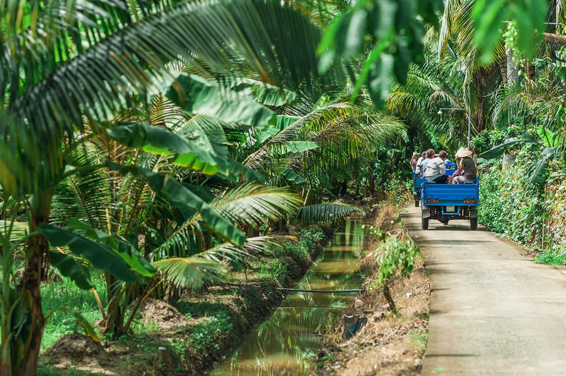
Ho Chi Minh City to My Tho
Start – Ho Chi Minh City; End – My Tho; Distance – approx 70km/44 miles
The rice paper-flat Mekong Delta doesn’t get much road trip love because its every-shade-of-green rice fields can turn from mesmeric to slightly monotonous as the miles mount up. However, once you get outside of sprawling, smoggy Ho Chi Minh City, you’ll start to see urban shrubbery give way to majestic palms and lush banana trees.
While the scenery here is certainly nothing to be sniffed at, the best part of driving in the Mekong Delta is taking your foot off the gas and losing yourself in the tiny riverside laneways and byways, where life moves at a very different pace to the buzzing streets of HCMC. When you eventually make it to My Tho, a town famed for its chewy noodle soup, further cultural experiences abound, with the flower farms of Sa Dec a short drive to the west and Can Tho, home to the largest floating market in the Delta, located to the southwest.
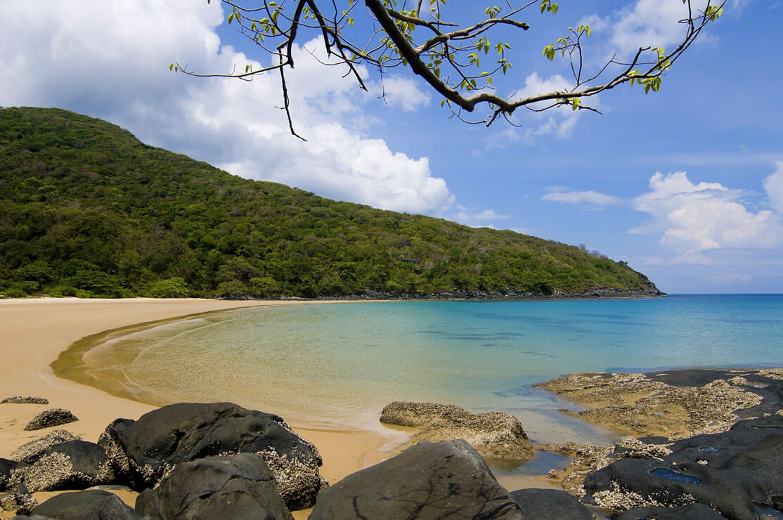
Con Son Island
Start – Dam Trau; End – Ben Dam; Distance – approx 25km/15 miles
Isolated from the mainland for years, the Con Dao islands are one of Vietnam’s natural wonders. Con Son, the largest and only inhabited island of the archipelago, has just one main road stretching across its length, making a motorbike trip here not only the best way to see the rural splendour of the island, but also the best way to beach hop your way from one gorgeous deserted spot to the next.
Start at Dam Trau, a long stretch of beach dotted by seafood shacks near the airport, and wind your way past forested hillsides, French colonial-era prisons, and glorious beaches that only appear during low tide, ending up at Ben Dam where ferries from the mainland come and go.

Ho Chi Minh Highway
Start – Ho Chi Minh City; End – Hanoi; Distance – approx 1880km/1168 miles
While there are several different routes between Vietnam’s two biggest cities depending on whether you like beaches, mountains or smooth highways, the one offering the best balance between driving time (about two weeks) and excellent scenery is the Ho Chi Minh Highway, part of which was once used to transport soldiers and supplies during wartime.
Follow the road along the Truong Son mountain range as it snakes its way past sleepy hamlets, where the smell of coffee from nearby plantations hangs thick in the air. From barren plateau rise forested mountains as you reach Central Vietnam, considered the most scenic stretch of this epic road trip. Adventurers will want to stop at Phong Nha Ke Bang National Park, home to the world’s largest cave, and Cuc Phuong, Vietnam’s oldest national park, located in the Red River Delta, before joining the throng of traffic on the ancient streets of Hanoi.
JAMES PHAM
Lonely Planet Writer